The Central Water Commission monitors the Glacial Lakes & Water Bodies in the Himalayan Region of Indian River Basins. Based on this data, between 2009 & 2021, the area of 146 water bodies has increased (by more than 5%), and that of 175 has reduced (by more than 5%), and another 135 have remained unchanged (change is less than 5%).
The Indian Himalayan Region (IHR), often referred to as the third pole of the world, boasts of the largest concentration of glaciers and snow outside the Polar Regions. Across the globe, studies have revealed that glaciers have been receding fast since the onset of the Industrial Revolution in the eighteenth century. As these glaciers thin and withdraw, they give rise to the expansion of glacier meltwater lakes and the creation of new ones. These lakes, nourished by glacier meltwater, are commonly known as glacial lakes. The formation of these glacial lakes typically occurs behind moraine or ice dams as the glaciers recede.
A glacial lake outburst flood (GLOF) is a sudden and often catastrophic release of water from a glacier-dammed lake. These events occur when the natural dam, often composed of ice and glacial debris, holding back the water in the lake fails, releasing a significant volume of water downstream. Rapid melting of glaciers as global temperatures rise, earthquakes, and avalanches are some causes of such occurrences.
In early October 2023, there was a sudden surge in flows in the Teesta River due to GLOF, which claimed the lives of many, along with severe infrastructural damage. It washed away several bridges, parts of NH-10, and the Chungthang Dam, and has impacted several small towns and infrastructure projects in the upper reaches of the river valley in Sikkim.
GLOF Risk in Sikkim was highlighted in many reports previously
However, this was not unprecedented. Many studies and reports had earlier flagged the region as highly vulnerable to GLOFs and emphasized on the need to conduct an environmental impact assessment and potentially undertake GLOF risk mitigation measures at least two–three years ago. Earlier this year, the Standing Committee on Water Resources report on Glacier Management in the country was presented in the Parliament. It ranked the lakes with a size of more than 1 hectare for GLOF risk considering glaciological, terrain, and associated characteristics. (Factly’s review of the report can be read here)
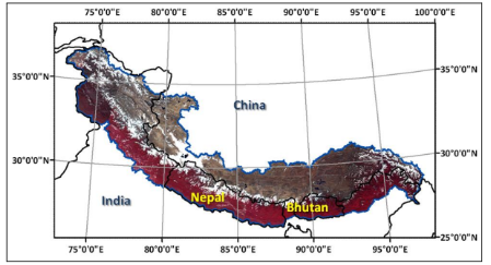
These lakes are spread out not just in India but over several other Himalayan countries including Nepal, Bhutan, and China. The region is a pristine source of freshwater in the entire Indian subcontinent which is vital for water supply, flood and drought mitigation, irrigation, groundwater recharge, livelihood source, tourism, and biodiversity. However, these lakes are being significantly affected due to climate-driven changes, natural processes, and anthropogenic activities. Owing to different reasons such as draining, rainfall, and rate of melting, among others over the years, the area of the lakes has either increased, decreased, or remained unchanged.
CWC monitors glacial lakes in India
In this story, we look at the change in the area of these glacial lakes and water bodies over a period of two decades, between 2009 and 2021. For this, data has been taken from Dataful where the information has been compiled from the Central Water Commission’s report. According to the report, the glacial lakes and water bodies in the Indian Himalayan region are monitored using satellite images. Some of the criteria for monitoring the glacial lakes and water bodies in the region are:
- Only glacial lakes & water bodies that are larger than 50 ha have been covered.
- The maximum water spread area for each water body among the different dates of satellite in the months of June to October 2021 has been considered for the final analysis of the change in water spread.
- A change in water spread area within +/- 5% is considered no change.
- Partly or fully cloud covered, or frozen water bodies have not been considered in monitoring.
- The spatial extent of the water spread area during the current month has been mapped and compared with the spatial extent of the water spread area mapped during 2009.
- For a particular year, the water spread area has been taken as the maximum of the area calculated during monitoring from June to October.
The area considered for the study is as shown:
467 water bodies with water spread area of 5.38 lakh hectares have been covered in the report
The data for 467 glacial lakes and water bodies have been identified in the report, across India, China, Bhutan, and Nepal. Majority of these, 328 were in China, 92 in India, 26 in Bhutan, and 21 in Nepal. The total water spread area of these water bodies was 5.38 lakh hectares, as of 2021.
Based on data available for both years, the area of 146 water bodies has increased (by more than 5%), that of 175 has reduced (by more than 5%), and another 135 have remained unchanged (change is less than 5%).
The data shows that 25 water bodies recorded an increase in water spread area by more than 40% between 2009 and 2021. A total of 37 water bodies recorded an increase in area by more than 30%. The area of the water body CH_33 in China (part of the Indus basin) has nearly quadrupled (388%). 219% increase in the water body HP_5 in Himachal Pradesh (part of Chenab River, Indus Basin) was recorded. CH_206’s area (in Ganga Basin) grew by nearly 159%.
The report highlighted that water bodies CH_6, CH_33, CH_39, CH_55, HP_3, HP_5 may affect Jammu & Kashmir including Ladakh, HP_3, HP_5, may affect Himachal Pradesh, CH_188, CH_206, CH_244, NP_64 may affect Bihar, SK_19, SK_20, SK_26 may affect Sikkim, AP_135, AP_206, CH_ 423, CH_ 590, CH_ 593, CH_ 834, CH_ 838, CH_ 849, CH_865, CH_1032, CH_1175, CH_1176 may affect Arunachal Pradesh & Assam respectively as they have shown increase in water spread area by 40%. Vigorous monitoring is necessary for these water bodies to avoid any future disaster. Continuous monitoring is required for those water bodies whose area has increased by more than 20%. The area of 42 water bodies has grown by 20 to 40%.
On the other hand, the areas of CH_373, CH_183, and CH_403 in the Brahmaputra and Ganga basins have reduced by more than 70%. The area of another 9 water bodies has been reduced by more than 40%.
About 35% of the water bodies in the Indus Basin recorded an increase in area
Of these water bodies, 35% in the Indus Basin, 32.5% in the Ganga Basin, and nearly 31% in the Brahmaputra Basin recorded an increase in area. While a majority of the water bodies, around 40%, considered in the Brahmaputra Basin and Ganga Basin saw a decrease in area, about 36% in the Indus Basin remained unchanged.
Area of nearly 30% of the glacial lakes and water bodies has increased
The area has increased for nearly one in three water bodies considered to be in the Himalayan Region lying in China while it is about 28% in the other countries. Area of the 30% of the water bodies in China, 40% in Bhutan, 28% in Nepal, and more than 25% in India has remained unchanged.
Of all the water bodies whose area has increased, 27% (7 out of 26) in India, 16% in China (17 out of 107), and 16.67% in Nepal (1 out of 6) have increased by more than 40%. Going by the criterion used in the report, these are the water bodies that require vigorous monitoring and have the potential to affect Indian states in the Himalayan region.
Increasing area of glacial lakes is an indicator of climate change
Himalayan lakes are crucial for the well-being of the local communities and for maintaining the ecological balance in the region. The changing area of these water bodies and glacial retreats are clear signs of increasing temperatures. These lakes, whose area is increasing, have the potential to pose a significant hazard in the form of Glacial Lake Outburst Floods (GLOFs). India along with Pakistan, Peru, and China account for more than 50% of the globally exposed population. Another research identified 207 glacial lakes as very high-hazard and 345 as high-hazard. Most of them are concentrated in the eastern and central Himalayas.
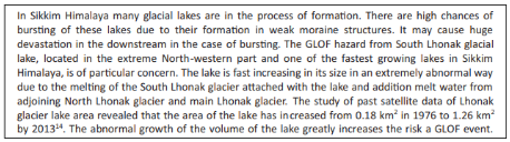
The National Disaster Management Authority (NDMA)’s revised National Disaster Management Plan (NDMP)- 2019 which addresses Glacial Lake Outburst Floods (GLOF) discusses these issues in detail. It had even flagged the GLOF hazard from South Lhonak glacial lake, located in the extreme North-western part and one of the fastest growing lakes in Sikkim Himalaya, as of particular concern. Yet, the disaster claimed many lives and infrastructure.
NDMA has also issued guidelines on Management of Glacial Lake Outburst Floods in October, 2020. The guidelines, among other things, contain roles and responsibilities, including actions to be taken by various stakeholders, which include agencies of Central and State Governments, for disaster risk management for GLOF. The State Government of Uttarakhand has Early Warning Systems and Automatic Weather Stations installed at various locations to protect the susceptible areas.
EIA and Mitigation Strategy is what India needs
The standing committee report submitted to the Parliament noted “Himalayan-Karakoram region is becoming warmer at a faster rate than global mean by 0.5 0C which will lead to local changes in hydrology in terms of rainfall and snowfall patterns, increased melting from glaciers and threat to the infrastructure due to increase in extreme events leading to disasters.” The National Green Tribunal in its order in 2019 has also held that addressing the issue of Climate Change and its effects do fall within the ambit of the Environment (Protection) Act, 1986. Such clear noting of these issues by the Legislature and Judicial bodies of India weighs more on the necessity of EIA and the mitigation strategies and measures to be taken with utmost priority.
Considering how glaciers and water bodies are constantly monitored by the government, researchers, scientists, and other institutions, it is clear that the institutional awareness of these risks is increasing. However, conducting environmental impact assessment and implementation of strategic mitigation measures is what is needed to tackle the situation going forward to reduce or even prevent loss of life & resources at the time of disaster like in Sikkim.