Glaciers are the most visible markers of climate change. A small rise in temperatures could melt away tonnes of ice. As the climate changes and glaciers melt, a lurking threat awaits- glacial lake outburst floods (GLOFs). In this story, we look at the Standing Committee on Water Resources report on the glacier management in the country presented recently.
Known as the ‘Water Towers of Asia’, the three main rivers- Indus, Brahmaputra, and Ganges, originate from the Hindu Kush Himalayas. These Himalayas span across central and south Asia, extending from Afghanistan in the west to Myanmar in the east. Due to its high ice quantity, these are also called the ‘Third Pole’. The glaciers present in these mountain ranges are an important source of water security for India. On the other side, they also pose an extreme threat to the populace of this region.
Glaciers are the most visible markers of climate change. A small rise in temperatures could melt away tonnes of ice. As the climate changes and glaciers melt, a lurking threat awaits- glacial lake outburst floods (GLOFs). These occurrences take place quickly, releasing enormous amounts of water within a short span. GLOFs can be incredibly destructive and can strike with little forewarning, resulting in considerable loss of life and damage to property, infrastructure, and agricultural land. It, therefore, becomes of utmost importance to manage these GLOFs to minimize the destruction.
In today’s story, we look at the Standing Committee on Water Resources report on the glacier management in the country presented in the Parliament in March 2023.
More than nine thousand glaciers in Indian Himalayas
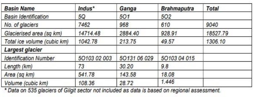
There are 9,040 glaciers in the Indian Himalayan region, according to the Himalayan Glacier Inventory maintained by the Geological Survey of India (GSI). The Indus Basin is home to more than 80% of these. The glacierized basins of the Indus, Ganga, and Brahmaputra contain a total of 1306.1 cubic kilometres of ice (or roughly 1110 cubic kilometres of water). There is no precise information available regarding the volume of ice and snow water separately. The information on the glaciers in the Indian Himalayan region is as depicted below.
Himalayan glaciers warming at a greater pace than global mean.
The glaciers in Indian Himalayan Region are retreating at a rate of 5 to 20 metres per year. The causes of this glacial retreat are both natural and man-made. The Himalayan glaciers are losing mass at a pace of 6.6 Gt annually, or around 0.2% annually. According to estimates made using satellite data, the Himalayas lost 13% of its glacier area between 1960 and 2000, or over 0.3% a year. Using satellite data from 2000-01 to 2010-11, ISRO has tracked the progress and retreat of 2018 glaciers in the Indian Himalayan area. According to the study, 87 percent of glaciers exhibited no change, 12 percent of glaciers receded, and 1 percent of glaciers advanced.
According to a recent study conducted across India, China, Nepal, and Bhutan, glaciers melted at a pace of 0.25 m per year from 1975 to 2000, but since then, the rate has increased to 0.5 m per year. The IPCC Report 2021 also reaffirms the decline in snow cover in Indian Himalayas.
According to data provided by DST, the Himalayan Karakoram region is warming by 0.5 degree Celsius more quickly than the global mean. Increased glacier melting results in altered rainfall patterns, impacting the biodiversity as well as the livelihoods of the mountain and downstream populations.
No timely studies done to access the melting of glaciers.
The importance of the Hindu Kush Himalayas is well documented. Yet, there are very few studies done to assess the impact of climate change on them. Even the data on the number of glaciers in the Indian Himalayas is from the special publication of GSI in 2009.
When the Standing Committee asked about the warming of Himalayan glaciers, the department replied that the Ministry of Environment, Forests and Climate Change (MoEF&CC) has not conducted any study or awarded any project on the warming of Himalayan glaciers. Further, upon asking whether smaller Himalayan glaciers are more sensitive to climate change, the Ministry agreed with that statement and held that the shrinkage rate of smaller Himalayan glaciers is higher than that of larger glaciers. However, a comprehensive study is needed to access the exact reasons for such retreating patterns of glaciers.
Legislative Framework for glacier management
Multiple agencies work in tandem in managing and monitoring the Himalayan glaciers, as detailed below.
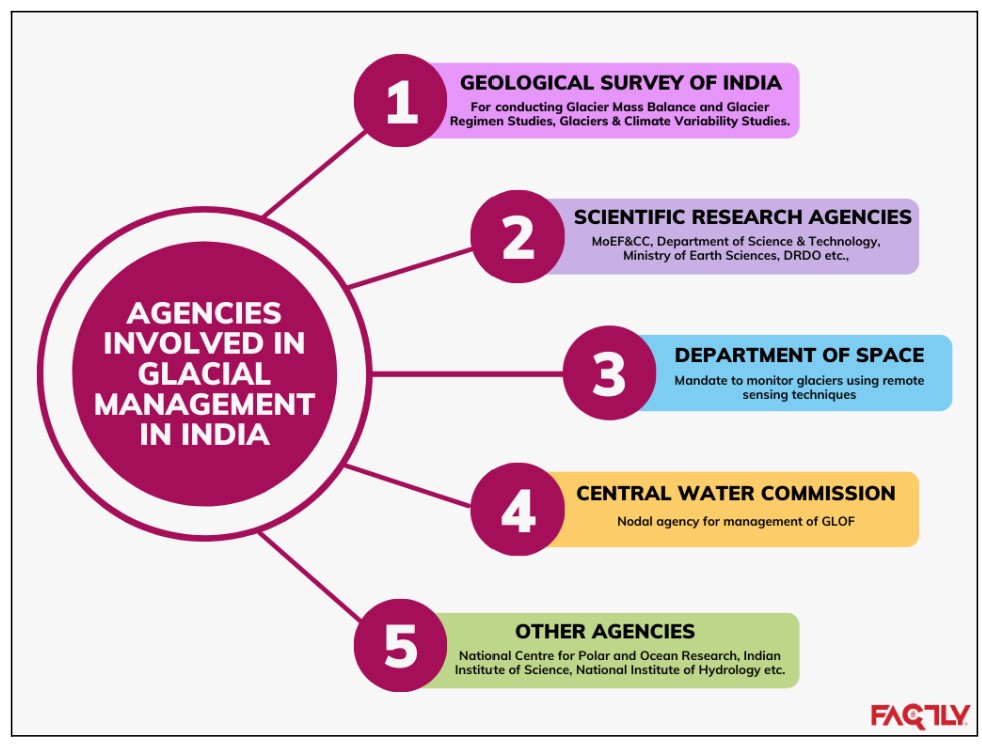
Further, the presence of multiple agencies in glacial management results in duplication of efforts. No demarcation of responsibilities among ministries and departments is done to date. As a result, coordination among agencies to streamline the efforts is difficult.
Monitoring of glacial lakes
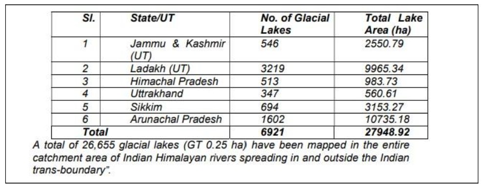
Indian Territory has a total of 9575 glaciers (9040 in the Indus, Ganges, and Brahmaputra basins plus the 535 glaciers of the Gilgit sector). Indian Territory contains 6,921 glacial lakes with a surface area greater than 0.25 hectares, detailed below.
There is no specific information on stretches of the Himalayans where the danger of melting of glaciers and consequent GLOF are most severe. Out of the total inventoried glacial lakes, the lakes with a size of more than 1 ha are ranked for GLOF risk considering glaciological, terrain, and associated characteristics. The details of prioritized ranked Glacial lakes for GLOF Risk are as follows: the Indus basin with 614 lakes and the Ganga basin with 864 lakes, and assessment is under progress for the Brahmaputra basin.
Management of glacial lakes
A comprehensive approach is developed for GLOF risk reduction in the “Guidelines on Management of Glacial Lake Outburst Flood (GLOF)” issued by the NDMA in October 2020. According to the NDMA, the Himalayan States don’t have a separate Disaster Management (DM) Plan. The revised National Disaster Management Plan (NDMP) was created by NDMA in November 2019 and includes, among other things, information on disasters that are likely to occur in the Himalayan region, such as landslides, earthquakes, glacial lake outburst floods (GLOF), as well as the roles and responsibilities of various stakeholders and the steps that should be taken to manage these disasters.
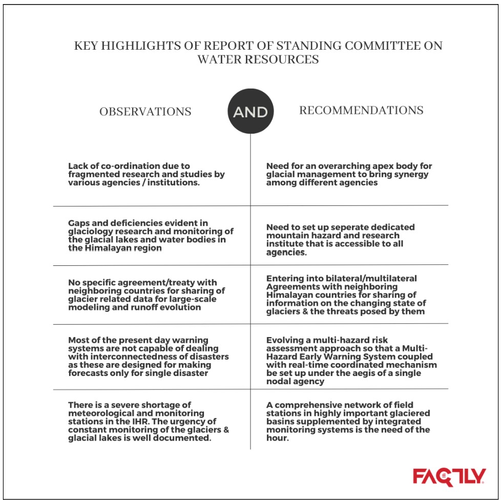
Some important observations and recommendations by the Standing Committee
The committee, based on the inputs from different agencies, made recommendations and asked the respective departments to apprise themselves of the progress made within a specific time period. Among them, general recommendations include the need for constant monitoring of the Indian Himalayan Region (IHR), assessing the adverse impact of black carbon, change in the land use regulations, and creating public awareness about the consequences of global warming. Apart from these, specific recommendations are detailed as below.
Way forward
We can undoubtedly anticipate more and larger glacier lakes on a warming planet. Outbursts from glacial lakes are already dangerous and destructive. Glaciers are anticipated to melt even more swiftly as temperatures continue to rise as a result of heat-trapping greenhouse gas emissions. With efficient early warning systems and careful planning, communities can lower the risk.
Featured Image: Glacier Management