Recently, the Department of Science and Technology released a report titled ‘Climate Vulnerability Assessment for Adaptation Planning in India Using a Common Framework’ which identifies the most vulnerable states and districts in India with respect to current climate risk and key drivers of vulnerability. 7 of the 8 most vulnerable states to ‘Climate Risks’ are the Eastern States
Recently, the Department of Science and Technology released a report titled ‘Climate Vulnerability Assessment for Adaptation Planning in India Using a Common Framework’ which identifies the most vulnerable states and districts in India with respect to current climate risk and key drivers of vulnerability. The assessment which is part of capacity building programme under two National Missions on Climate Change- National Mission on Sustaining the Himalayan Ecosystem (NMSHE) and National Mission on Strategic Knowledge for Climate Change (NMSKCC), is a result of the joint efforts of the Indian Institute of Technology (IIT) Mandi, Indian Institute of Technology (IIT) Guwahati, Indian Institute of Science (IISc) Bengaluru, Climate Change Programme (CC) – SPLICE Division, Department of Science & Technology (DST) and the Swiss Agency for Development and Cooperation (SDC).
Climate risk varies across regions
Rising sea levels, increased temperatures, extreme weather events, and others are a result of climate change which has severe consequences on biophysical systems like forests and rivers, as well as socio-economic systems such as livelihoods and agriculture. The impact of climate change is not uniform and varies across regions due to different factors some of which are urbanization, environmental degradation, level of exposure, demography, social conditions, and economic parameters. Different regions hence have different vulnerabilities. The Intergovernmental Panel on Climate Change (IPCC) defines vulnerability as ‘the propensity or predisposition to be adversely affected’.
Identifying vulnerable regions helps in adaptation planning and investment
Carrying out such vulnerability assessment would help in identifying areas that are more prone to the consequences of climate change and hence greater attention can be paid to these areas while devising mitigation and adaptation strategies, preparedness, adaptation planning, and prioritizing action. Furthermore, it is critical for developing adaptation projects for the Green Climate Fund, Adaptation Fund, and funds from multilateral and bilateral agencies. The findings from the report are also helpful to facilitate Nationally Determined Contributions, which aims to adapt better to climate change by enhancing investments in development programmes in sectors vulnerable to climate change, particularly agriculture, water resources, health sector and regions such as the Himalayan and coastal regions, etc.
Vulnerability has been analysed in 29 states including erstwhile Jammu & Kashmir
The assessment was carried out in 2019-20 across 29 States including the erstwhile state of Jammu and Kashmir. States and districts have been ranked on the basis of the vulnerability index which has been calculated using secondary data concerning biophysical, socio-economic, and institution and infrastructure-related vulnerability indicators. Indicators have been shortlisted based on data availability. Data between 2011 and 2019 has been used for arriving at the index score. The 14 indicators used for all-India state-level analysis are the following.
Jharkhand is relatively the most vulnerable state to climate risk
State-wise climate vulnerability index (VI) ranges from 0.42 to 0.67 which implies that all states have to deal with issues related to climate vulnerability. Jharkhand had the highest VI of 0.67 while Maharashtra had the lowest of 0.42. It is important to note that the measure is relative. One cannot conclude that Maharashtra is not vulnerable. The VI ranking shows that Jharkhand is relatively the most vulnerable state to climate risks while Maharashtra is the least vulnerable in relative terms.
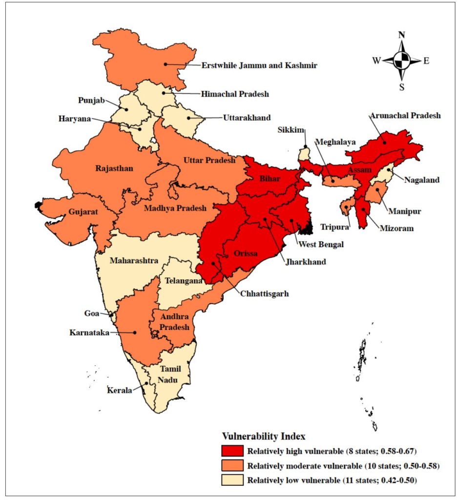
7 out 8 most vulnerable states are in eastern part of the country
Jharkhand, Mizoram, Odisha, Chhattisgarh, Assam, Bihar, Arunachal Pradesh, and West Bengal in that order have been identified to be the most vulnerable states. Except for Chhattisgarh that lies in Central India, the remaining seven states lie in the eastern part of the country.
Uttar Pradesh, Tripura, Gujarat, Meghalaya, Jammu and Kashmir, Rajasthan, and Madhya Pradesh are in the category of ‘moderate vulnerability’ with their VIs ranging from 0.528 to 0.582. Manipur, Andhra Pradesh, and Karnataka also fall in this category, with VIs between 0.503 to 0.52.
Himachal Pradesh, Telangana, Sikkim, Punjab, Uttarakhand, Haryana, Tamil Nadu, Kerala, Nagaland, Goa, and Maharashtra are the states with low vulnerability as per the index. Their VI is below 0.5. Three out of the five southern states fall in the low vulnerability category.
Most of the highly vulnerable states have low per capita income and low HDI
Vulnerability is multi-dimensional. The drivers of vulnerability can be different for different states as noted in the report. The reason behind the high vulnerability of Jharkhand is the higher proportion of BPL population, the prevalence of rainfed agriculture, and high incidence of vector-borne diseases while in Odisha, the prevalence of marginal and small landholdings, lack of forest area, and vector-borne diseases incidence caused the index to be high. Overall, the main reason behind the highly vulnerability of the eight states is that most of them are poor states with a low per capita income and low Human Development Index. Lack of forest cover, high disease prevalence, and lack of an adequate number of health care workers also drive the vulnerability in these states. Further, a higher proportion of the BPL population, rainfed agriculture, and lack of crop insurance are other factors affecting vulnerability.
Lack of forest was major driver in states with low and moderate vulnerability
As per the report, each state can have more than one indicator which drives their vulnerability index. In the moderately vulnerable states, the lack of forests per 1000 rural population is what drives their vulnerability. One in three health indicators lacked in each of these states. However, the lower proportion of BPL population, better implementation of MNREGA and their road-rail network are the indicators that reduce the vulnerability of these states.
Meanwhile, in the states with low vulnerability, it can be seen that lack of forest area per 1000 rural population, lack of crop insurance, and the prevalence of rainfed agriculture are what drove their vulnerability. These states are not highly dependent on natural resources for their income. Their infrastructure, health indicators, and MGNREGA implementation are way better than the other states.
Looking at all the states irrespective of the level of vulnerability, lack of forest area is the main driver of vulnerability in 17 different states followed by lack of crop insurance and prevalence of rainfed agriculture in 11 states. Only one state, Arunachal Pradesh recorded MGNREGA implementation as a major driver.
19 out of 27 districts in Assam were among the 50 most vulnerable districts
The district-wise vulnerability assessment is based on 612 districts, which cover the same geographical area as the current 718 districts. The recent bifurcation of districts in various states has not been included due to data unavailability for the indicators
District-wise VIs ranged from 0.34 in Lahul & Spiti in Himachal Pradesh to 0.75 in Karimganj in Assam. Hence, all the districts have to deal with concerns related to vulnerability. Ranking on the basis of vulnerability of these districts, from high to low, shows that the four most vulnerable districts are in Assam and the 13 most vulnerable districts are either in Assam or Bihar. 19 out of 27 districts in Assam were among the 50 most vulnerable districts and 15 out of the 38 in Bihar figure in the top 50 vulnerable districts.
Assam (92.6%), Bihar (81.6%), and Jharkhand (62.5%) have over 60% districts in the category of highly vulnerable districts. Not a single district from Arunachal Pradesh, Chhattisgarh, Goa, Gujarat, Himachal Pradesh, Kerala, Meghalaya, Nagaland, Sikkim, Punjab, Rajasthan, Tripura, and Uttarakhand were in the highly vulnerable category.
Low sown area under horticulture was the major driver of vulnerability in 392 districts
Among the various drivers, the low sown area under horticulture was the major driver of vulnerability in 392 districts followed by lack of forest are per 100 rural population in 336 districts and lack of crop insurance in 306 districts. The net sown area under horticulture was low for 109 districts out of the 153 most vulnerable districts. Lack of forest area per 100 rural population is found to be a major driver in 99 highly vulnerable districts. Only 15 districts had recorded poor health infrastructure as the major driver of the 612 districts. Likewise, Female Literacy Rate was the major driver in 16 districts.
The indicators used for the assessment have been adjusted to ensure data availability. According to the DST’s press release, there are plans to even conduct assessment of Hazard and Exposure to arrive at overall climate risk.
India had most fatalities due to climate change globally in 2018
The German Watch Global Climate Risk Index- 2019 has ranked India 5th out of 181 countries, which means that India has an extremely high exposure and vulnerability to climate change and associated risks. India fell from its 14th rank in 2017 of the countries hit most by climate change-induced weather phenomena. Furthermore, India has also recorded the highest number of fatalities due to climate change and the second-highest monetary loss from its impact in 2018.
Most reports identify India as one of the countries facing a high risk of climate change. The immediate focus must be given to come up with effective mitigation and adaptation strategies to minimize risk in the coming years. The climate vulnerability assessment is a step in the right direction, the analysis of which should be used to devise the right kind of mitigation strategies.
Featured Image: Climate Vulnerability Assessment