Data from the EnviStats India 2022 indicates that India’s overall Mangrove cover has increased to 4,992 square kilometres by the year 2021 compared to 4,046 square kilometres in the year 1987. However, as per the government’s official sources, India has lost about 40% of mangrove forest area in the preceding century before the year 1987.
The Mangroves and their ecological importance are not only widely acknowledged, but also scientifically proven across the globe. According to the National Disaster Management Authority (NDMA), the Mangroves are extremely important to the coastal ecosystems. The wide variety of their ecological services includes serving as biodiversity hotspots, maintainers of water quality, sequesters of carbon, and providers of livelihood, among many others. They also serve as a buffer between marine and terrestrial communities and protect shorelines from damaging winds, waves, and floods. Because of these diverse benefits, the Ministry of Environment, Forests and Climate Change (MoEF&CC) recognizes them as also being called as ‘Tidal Forests’, ‘Coastal Woodlands’, ‘Walking Forest in the Sea’, ‘Root of the Sea’ and ‘Oceanic Rain Forests’.
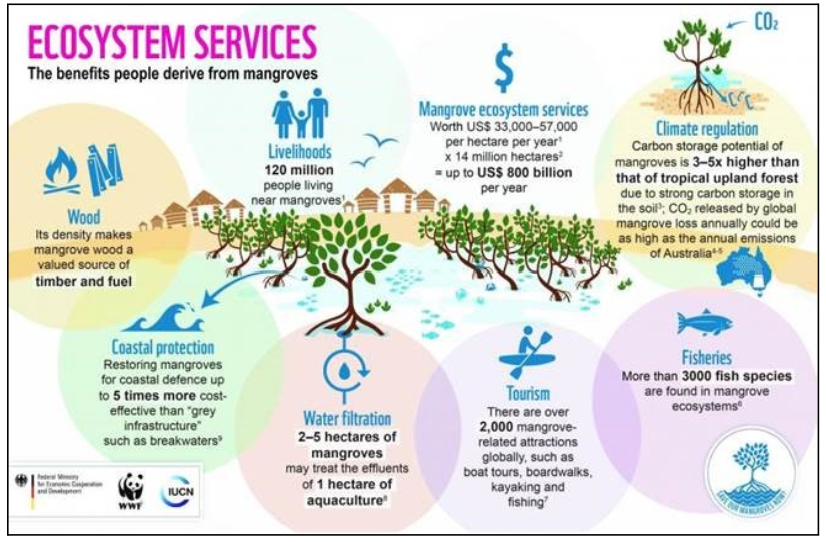
Therefore, the importance of mangrove protection, preservation and increasing their cover, especially in the contemporary world of climate change is emphasized by many nations globally. The NDMA itself recognizes that conserving and restoring mangroves is essential to fighting climate change, and the warming of the global climate.
The recently published 2022 edition of the Environmental Statistics Data of the Ministry of Statistics and Programme Implementation (MoSPI), which is sourced from the Forest Survey of India’s (FSI) State of Forest Report, 2021, shows several important aspects related to the status of mangroves and their coverage in India. In this story, we look at these statistics.
Methodology
The data has been sourced from Mangrove Datasets from Dataful which has been in turn compiled from the information published by MoSPI and FSI. These datasets are used for analysis in this story.
Data shows Increase in Mangrove Forest Area, but the Original Loss has not been fully Restored
The data shows that India’s overall Mangrove cover in the year 1987 was 4,046 square kilometres or 404600 hectares. This has increased to 4,992 square kilometres by the year 2021. Therefore, in nearly 4 decades, the Mangrove has increased by 946 square kilometres.
However, as per the government’s official data itself, India lost about 40% of its mangrove forest area in the preceding century before the year 1987. Therefore, when compared to India’s overall coverage of 4,046 square kilometres in the year 1987, India has lost 1618.4 square kilometres of Mangrove Forest area. Thus, although the overall figure in the last four decades has increased by 946 square kilometres, the remaining about 672.4 square kilometres, which is about 41.5% of lost Mangrove Forest, has not been compensated yet.
Very Less area of Higher Canopy Cover, bulk of Forest is under Degraded Status
The Mangrove cover data has also been classified by quantity of canopy cover as Very Dense, Moderately Dense and Open Mangrove Forests. As per the official definition, the mangrove forests with 70% or more, 40% to 70% and 10% to 40% canopy cover are classified as Very Dense, Moderately Dense and Open Forests, respectively.
The analysis of the data shows that from the year 2003 to 2021, the area under Very Dense and Open Forests has increased from 1162 to 1475 and 1632 to 2036 square kilometres, respectively. However, the area under Moderately Dense Forest has decreased from 1657 to 1481 square kilometres. Thus, the data shows that out of the total 4992 square kilometres of Mangrove Forest as of 2021, the area under less than 70% of canopy cover is 3,517 square kilometres, which accounts for 78% of the total Mangrove Forest area. Within this, the area under less than 40% canopy cover is 2036 square kilometres, which is about 45% of the total mangrove forest area. Therefore, the mangrove forest with very dense or higher canopy cover is only 22% even as of date.
Further, the MoEF&CC defines all forest lands which have a canopy cover of less than 40% as degraded forest land for Compensatory Afforestation (CA). As per the same definition, 45% or 2026 square kilometres of existing mangrove forests in India fall within the category of ‘Degraded Forests.’ Therefore, as per the official definition itself, the bulk of the mangrove forest cover in India is under the status of degradation.
Only 1 in every 7 coastal districts have Higher Canopy Cover Mangroves
India has 9 states and 2 union territories with coastal belt, with a total of 55 coastal districts. As per the data, there are only 8 districts in 4 states and 1 union territory which have very dense mangrove forests, as of 2021. Therefore, on average, only one district in every seven coastal districts of India has a higher canopy cover of 70% or more.
Further analysis of the data also shows that while Odisha and Karnataka have one district each with very dense mangrove forests, the other states viz. West Bengal, Tamil Nadu, and Andaman and Nicobar Islands have 2 districts each. Among these states, the data shows that the area under very dense mangrove cover in Karnataka and Tamil Nadu states is as low as 0.09 and 1.11 square kilometres, respectively. Therefore, even among the 5 states that have higher canopy cover, 2 states have an almost negligible proportion of the same. The state that tops the list is West Bengal with 994.31 square kilometres, followed by Andaman and Nicobar Islands and Odisha with 398.73 and 80.43 square kilometres of mangrove forests, respectively. Thus, out of the 11 states, only 3 states in India have mangrove forests with reasonably higher canopy cover.
15 coastal districts neither account for Very Dense nor Moderately Dense Forests
The further analysis of the data also shows that 15 out of the total 55 coastal districts with mangrove forests neither account for Very Dense nor Moderately Dense forests. Further, 40 out of the total 55 coastal districts account for only moderately dense and open forests. Even among the 40 districts, 17 and 5 districts account for 1 to 5 and 5 to 10 square kilometres of moderately dense forests, respectively. Therefore, the data shows that 22 out of the 40 districts have below 10 square kilometres of moderately dense mangrove forest area. Overall, there are only 3 and 4 districts with over 50 and 100 square kilometres of moderately dense forests in India.
Robust Measures for Increasing Mangrove Forests and Higher Canopy are the need of the Hour
The above data and analysis show that although there is an overall increase in the area of mangrove forests in India, the overall canopy cover and number of districts with higher canopy cover are still lower. It is also implied by the fact that the average area of very dense, moderately dense, and open forests of all the 11 coastal states stands only at 134.06, 134.62 and 185.15 square kilometres, respectively. Further, the average mangrove cover per each coastal state and district stands out as 453.84 and 90.76 square kilometres, respectively. Thus, when compared to India’s overall coastal length of 7,516 kilometres, the overall mangrove forest cover stands low. Furthermore, as mentioned earlier, India is still short by 672.4 square kilometres in compensating for the original loss of Mangrove forests before 1987. Thus, these facts call for robust measures to restore and increase the mangrove forest area and their canopy cover.
The immediate necessity for robust measures is also substantiated by the prevailing issue of coastal erosion which is being experienced at a higher rate in India. The National Centre for Coastal Research’s (NCCR) recently published report on shoreline changes showed that out of 6,907 kilometres of coastline among 11 states (including 2 union territories) which has been studied for shoreline changes, about 2318.31 kilometres of shoreline is undergone erosion varying from low to moderate and high erosion from the year 1990 to 2018. Therefore, the data clearly shows that in about 3 decades, over 33% of the Indian coast has undergone and continuing to undergo erosion. Yet another NCCR report of 2016 provides district-wise details of coastal erosion which has taken place by the year 2016. The analysis of these NCCR reports and the FSI reports of mangrove forest cover reveal that there are several coastal districts which do not have mangrove forests with higher canopy cover, and which have undergone and continue to undergo erosion.
Hence, the full restoration and increasing of mangrove cover with higher canopy cover is the need of the hour in India to mitigate and address issues such as coastal erosion among others.
Protective and Progressive Measures with Community Involvement could pave the Way
It is an officially acknowledged fact that due to climate change, compared to the pre-industrial era, the global temperature has increased by about 1.1 degrees census. In India, the mean temperature rise in the last century is 0.7 degrees. The consequential impacts of this climate change have been experienced across the globe and in India. These include serious issues such as seasonal imbalances, more than normal cyclones, floods, wind speeds, etc., impacting various sections of society. The worst affected still are the coastal and other communities that depend on mangroves and seas for their livelihoods. One of the proficient ways to mitigate and address some of these is to raise mangroves which are known to be climate resilient, and mitigate coastal erosion, among other benefits.
Therefore, it requires a collective effort with the involvement of the dependent communities in protecting and raising the mangrove cover. Both in India and across the globe, some initiatives of mangrove protection and raising are taking place through the involvement of local communities. In India, there are a couple of such initiatives named Conservation and Management of Mangroves and Coral Reefs (CMMCR) and Enhancing Climate Resilience of India’s Coastal Communities (ECRICC). Such initiatives are also taking place in some other countries. These are implemented by respective governments with other agencies such as UNDP, etc.
However, in terms of the larger prevailing issues in India, more such initiatives with effective implementation are necessary. The recent initiative called District Environmental Plans (DEP), aimed at addressing district-level environmental issues, could be utilized to address the issue of mangroves protection, and raising. The CPCB has issued an order on the list of environmental issues which can be taken up under DEP at the district level. Although the document does not explicitly state that coastal protection measures or mangrove forest raising can be taken up under DEP, it however gives the discretion to local authorities to take up the issues which are more important than those enlisted in the document. Therefore, under DEP, some of the coastal district authorities can consider protecting and raising Mangroves Forests through the involvement of local communities and others.