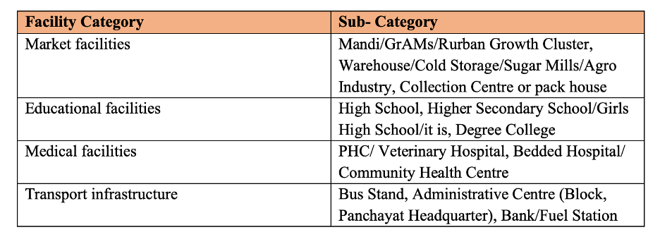
Under the Pradhan Mantri Gram Sadak Yojana (PMGSY), data of over 7 lakh geo-tagged facilities at the habitation level were recently released by the government. Three major facilities namely Market facilities, Educational facilities & Medical facilities were mapped under this exercise.
The Pradan Mantri Gram Sadak Yojana (PMGSY) was launched in December 2000 as a one-time special intervention to provide rural connectivity by constructing all-weather roads to unconnected habitations with the prescribed population. Road connectivity is a pivotal facilitator of growth and enables the achievement of many developmental goals. The first and second phase of the government’s flagship rural road development scheme focused on construction and upgradation of rural roads respectively. In 2019, the Central government approved the implementation of Phase III of the programme under which it aims to consolidate 1.25 Lakh kilometres of existing Rural Road Network and the upgradation ‘through routes’ and ‘major rural links’ that connect habitations to
- Gramin Agricultural Markets (GrAMs)
- Higher Secondary Schools
- Hospitals
The government has identified the three mentioned critical facilities as pivotal. Priority will be given to identifying and upgrading routes and links to connect the agriculture warehouses, government hospitals, and educational institutions. This would enable easy and faster movement to and from food processing centers, provide affordable and easy access to schools and medical facilities, which are necessary for the socio-economic development of a region.
GIS mapping of critical facilities has been conducted for identification of routes under PMGSY
In order to select candidate routes and identifying Major Rural Links/Through Routes, routes connecting each habitation in a Block to the nearest mandi/school/health facility would be traced and those which are common to many habitations will be identified by the States as candidate roads. As per the guidelines, this exercise is to be carried out preferably through GIS or manually. The exercise is useful for planning relevant investments.
Data of over 7 lakh geo-tagged facilities was opened by government recently
Recently, the data of about 7 lakh geo-tagged rural facilities across India under PMGSY was opened for public use. In other words, PMGSY released the data for anyone to freely use, re-use, or share the data provided it is attributed to the provider, and license as per Government of India’s Open Data License. The release of such a large GIS dataset is an important step forward as it helps in enhancing transparency. Such data is also important in planning and encourages public participation. Such data can be combined with other existing data for further research.
The data is available up to the habitation level in each state (data for some states is not completely available) and includes names of the facility, habitation name, address, category (such as transport or education), sub-category (such as Bank or High School), and its geographic coordinates (latitude and longitude).
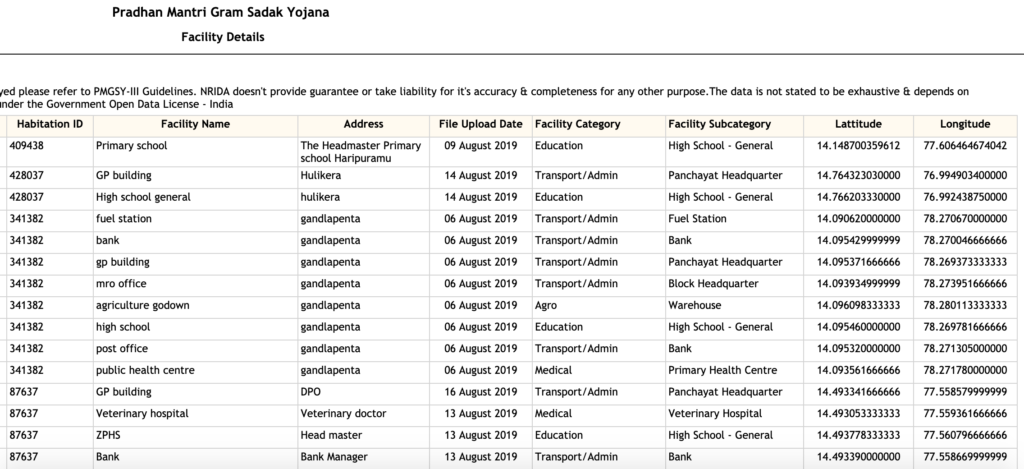
The list of facilities covered under the survey is given in the table below.
OMMAS software is being used for monitoring the implementation of PMGSY
OMMAS or the Online Management Monitoring and Accounting System is the web-based software being used for the implementation of PMGSY. The website provides the details of fund releases, fund utilization, the status of work progress, etc. and is available in the public domain. The geo-spatial data of facilities opened recently can be readily downloaded for each state from OMMAS. Of the data of over 7.71 lakh facilities, 1.53 lakh are Agro facilities, 1.7 lakh are educational institutions, over 88,500 are medical facilities. More than 3.58 lakh facilities are transport/admin related facilities.
Definition of facilities is not standardized
The data collection began in 2019 and is still in progress in some states like Uttarakhand, Himachal Pradesh, Nagaland, and certain other north eastern states. Meanwhile, data for Goa and most union territories is unavailable since they are yet to be integrated into the scheme. The data was collected by government rural engineers at the block level using a common android application. However, no prior centralized training or SOP was issued as a result of which there can be variations in collected data since the interpretation of the term facilities under each category is left to the persons collecting the data.
For instance, some states may have included private facilities on the list. The case may be that some states may not have considered weekly markets while collating the data on agro facilities, which is also critical in rural areas. But the facilities under education such as High Schools, recorded across the country need not be highly variant. Only what the surveyor deems fit to be considered in the collation, will be included. Some surveyors may have even used the definitions given in the census. States do not have records of what has been considered while collecting the data. This may act as a hindrance in the analysis and comparison of the data across states.
No standard device used for recording GPS
Another potential issue could be the inconsistency arising out of the use of different devices for capturing GPS coordinates. Use of different models of devices and varying accuracy can affect the longitude and latitudes recorded for this purpose since devices should be calibrated from time to time for recording accurate GPS coordinates. Mistakes while labelling sub-categories is another issue observed in the data. An example could be High Schools have been labelled as sub-categories under agro related facilities in Guntur, Andhra Pradesh, and Kolhapur, Maharashtra.
Geo-spatial data for different types of facilities is already available for some states
Geo-spatial data is already available in the public domain for some states & facilities. Telangana’s and Maharashtra’s GIS data on warehouses are different in the form of availability. While Telangana’s data is available in a tabular format, Maharashtra’s data has been mapped using different legends for different sub-categories of warehouses and agro related facilities. Similarly, Andhra Pradesh has geo-spatial data mapped for different health facilities in the state. Punjab has a single GIS dashboard where the user can choose to look for what they require from many options like irrigation, tourism, wetland, sewa kendras, and more, in addition to the three focused in PMGSY. The central government also maintains a GIS portal for schools which helps one in locating schools by category, facilities etc.
Improving quality of this data should be the next step
From the perspective of the PMGSY scheme, the data collated by the government is of grave importance. Opening of this data is also an important step forward considering the lack of such granular data in the public domain. In terms of planning, the variation in the availability of facilities across states can be taken into consideration. However, for such datasets to become really useful, many gaps need to be filled including improving the quality of the data. The process of nation-wide data collation is a cumbersome, time- consuming and an expensive exercise. Considering the huge investment and efforts required to generate such large datasets, steps should be taken for standardization of devices and definitions, better coverage, and increased accuracy.